Will this be a summer for the history books? Average global temperatures were the hottest on record last month, ranging about 0.10°C (or 0.18°F) higher than that of the previous record-holder, the Copernicus Climate Change Service reported Tuesday.
Three years earlier, the most sweltering June ever logged followed a strong El Ni?o event – a warming of the ocean surface in the central and eastern tropical Pacific Ocean, according to the service, which is tasked with providing comprehensive climate information for the European Union.
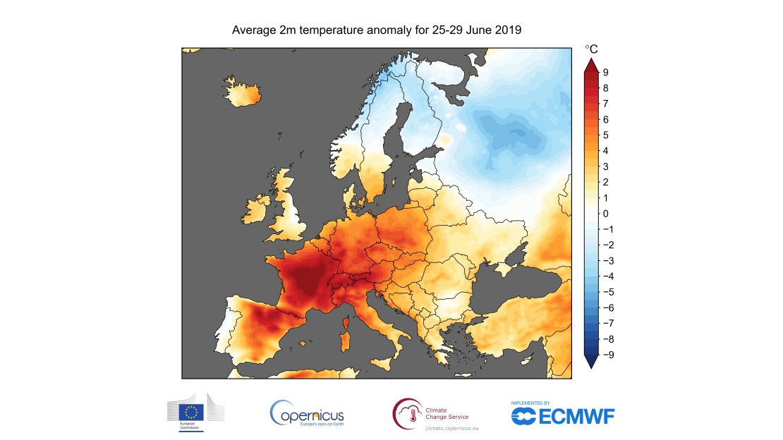
European thermometers also told a story of “hottest ever” last month.

Average continental temperatures ranged about 1°C above the previous record for June, set in 1999, and about 1°C higher than expected from the trend established in recent decades, according to Copernicus Climate Change Service. This short heat wave, less than one week, caused by hot air coming from the Sahara Desert, was extreme if not as unrelenting as that of the heat wave blanketing Europe in 2018, when average temperatures were higher than normal during every month from April to December.
“Such extreme weather events are expected to become more common as the planet continues to warm under increasing greenhouse gas concentrations,” according to Copernicus Climate Change Service.
Some gases, including carbon dioxide and methane, trap heat in the Earth’s atmosphere, producing a “greenhouse effect” which makes the planet warmer. Climate scientists say that our globe is 1°C hotter today than it was between 1850 and 1900 and that this is due in part to gas emissions from cars, planes and other human activities.
Meanwhile across the pond, the United States prepares to celebrate Independence Day during what the US National Centers for Environmental Information describes as the “hottest month of the year for the contiguous United States.” July is also the second month of the North Atlantic hurricane season and is the fourth most active month for tornadoes.
“The July temperature for the contiguous United States has warmed at an average rate of 1.1°F per century since 1895. Since 1950, the rate of change is just more than double that at 2.3°F per century,” according to the national information centers. July temperatures average 73.6°F (or 23.1°C)across the so-called Lower 48.
However, the most recent US climate report showed that May was cooler, not warmer, than usual. Average May temperatures in the 48 contiguous states was 59.5°F, about 0.7°F below the 20th century average.
Similarly, average temperatures during the first five months of 2019 across the Lower 48 was 43.4°F or just 0.1°F above the 20th century average, which is middle of the road, in terms of statistics.
Average temperatures may be unexceptional in 2019, but the weather extremes seen in the United States are changing character. Along with most of North America, the nation is experiencing more unusually hot days and nights and fewer extremely cold days and nights, the US Climate Change Science Program reported recently. Heavy downpours are becoming more frequent in some areas, while droughts also turn more severe in some regions.
In one way, though, May in the United States was extraordinary: The fifth month of 2019 ranked second wettest May in the 125-year record period and second wettest of all months since January 1895.


