Story highlights
Los Angeles is one of the most congested cities in the United States
Skeptics doubt whether expanding local transport systems will ease congestion
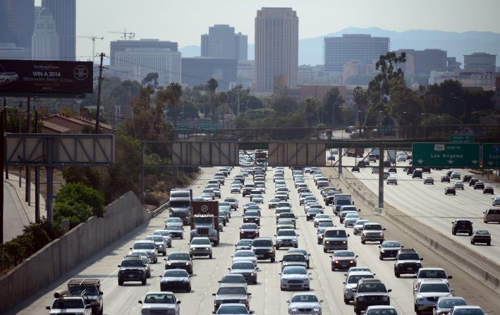
Los Angeles is probably as famous for its traffic congestion as it is for the iconic Hollywood Sign.
Last November, for example, CNN posted the below video, showing traffic congestion snaking for miles in LA just before Thanksgiving weekend kicked off.
Despite the planned expansion of the Los Angeles Metro Rail system, and the popularity of “walkable communities” such as Playa Vista in the Westside and the beachfront neighborhood of Santa Monica, LA’s congestion levels are still among the worst in the world.
“One of the things that has characterized Los Angeles over the past quarter century is that the metropolitan area has been continuing to grow,” says Brian D Taylor, director of the Lewis Center for Regional Policy Studies and the Institute of Transportation Studies at the UCLA Luskin School of Public Affairs.
“It’s portrayed in media and movies as a city of sunshine and palm trees, and tracts of single-family houses stretching off into the horizon – when actually, as an urbanized area, it’s the densest in the country, more so than New York.”
The root of the problem
Drivers in LA spent, on average, over 102 hours in traffic at peak times in 2017, according to transportation analytics firm Inrix – that’s the most time drivers spent in rush-hour jams in any city in the world.
Other US cities such as New York City and San Francisco suffer from similar levels of overall congestion as LA, according to Inrix. Their geographic areas, however, are much smaller than that of LA, meaning that drivers have a shorter commute, and hence spend less time in congestion during rush hour.
Furthermore, in metropolitan LA, 84% of commuters chose to drive or carpool to work in 2017, according to Inrix. It’s no wonder LA is known as a “driving city.”
Highway to hell?
The five most-congested segments of the city are all on its highways – specifically, on Interstate 405, which connects north and south LA, and US Route 101, a major highway that crosses the West Coast.
“Los Angeles and Southern California, in general, have relatively poor (public) transit services,” says Michael G McNally, a professor at the Institute of Transport Studies at the University of California, Irvine. “There really aren’t options (other than) cars for most travel in most areas. But even within transit-served areas, overall travel times are much greater by transit than by car.”
In 2016, LA voters passed the $120 billion Measure M ballot to expand transit capacity and improve highways throughout the region. The project aims to reduce time spent in traffic by 15% a day by 2057.
But Taylor doesn’t believe improving public transport facilities will work.
“If you build all this transit, will it relieve congestion? The answer is no,” he says. “Because the demand is still there. You can make all the improvements in public transport in the world, but if people can drive (from the suburbs) to their destination … the reality is (driving is) always going to be a more attractive way to get around.”
Read: Downtown Los Angeles’ stunning comeback
Is car ownership a factor?
Los Angeles County covers about 4,060 square miles and had an estimated population of 10 million in 2016, according to the US Census Bureau.By comparison, New York City had an estimated population of 8.5 million in 2016, squeezed into roughly 300 square miles of land.
Despite having less space to house a similar population size to LA, New York still doesn’t have it as bad when it comes to congestion. One of the reasons is car ownership: LA had an estimated 7.8 million vehicle registrations in 2016, whereas New York had just 2.6 million in 2015.
“We have developed, by choice, a car-dominated infrastructure (in LA) that will be no easier to change than trying to impose a road system in Venice, Italy,” McNally says.
“New York City has extreme population and employment density in the core, but it drops off rapidly as you move out radially. In LA, development densities are high for the entire region – (it’s) essentially a flat surface where most of a very large area is equally dense, and thus equally congested.”
The high cost of parking, combined with the wide-reaching, 24-hour public transit system in New York limits car ownership there, McNally adds.
Read: How do you solve a problem like Jakarta’s gridlock?
To build or not to build?
LA County has 6,500 centerline miles of streets, significantly more than some other US cities known for their congestion, such as Portland and Denver. But while you might think more road capacity means less traffic, that’s not actually the case, according to a report published by the National Center for Sustainable Transportation at the University of California, Davis in 2015.
It found that adding highway actually increases vehicle miles traveled (VMT), or the amount of vehicles within a region over a certain time frame.
This catch-22 is called “induced travel:” travel time initially decreases following an increase in road capacity, which lowers the costs associated with driving. This attracts more drivers and, in the end, that offsets the positive effects of the road expansion.
Changing landscapes
So how will LA’s traffic landscape look in the coming decades? McNally believes the car will still be king.
“People with a choice weigh many factors, including convenience and habit, and the simple fact that once you are sitting in your car you are essentially ‘home’ – which cannot be achieved in transit until you are actually ‘home’,” says McNally.
“The bottom line is car travel faces congestion, but (public) transit (in Los Angeles) essentially is not an option.”


